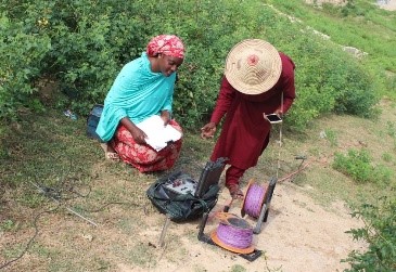
 PhD student Zaharatu Babika, from the WEIR research unit in the Department of Architecture and Civil Engineering, went for a pilot study as part of her project to investigate groundwater vulnerability and risk of contamination by identifying areas that are vulnerable to contamination in northern Nigeria, Africa, from 25th July to 20th August 2019. There are different sources of contamination that affect the quality of groundwater, which has been the only source of drinking water to more than 3,931,300 estimated population within the region, who didn’t have access to safe drinking water. Nearly 1,000 children die due to unsafe drinking water. The field survey started with identification of groundwater potentials across the region with the help of a member of staff named Mr Suleiman from the Ministry of Water Resources, Kano, Nigeria. An electromagnetic instrument was used to indicate the groundwater potentials among various communities. Below is an image of myself and Eng. Suleiman.
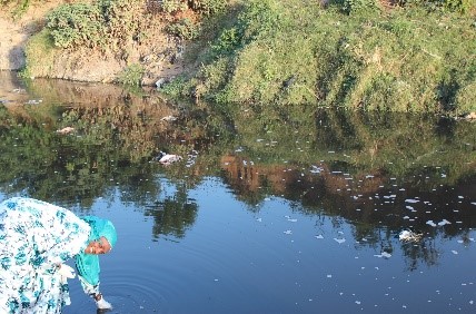
Groundwater contaminant sources are diverse. Interaction with Kano state Ministry of Environment’s official Mr Sabitu revealed different sources of contamination across the region, such as dumpsite sites, waste water having been discharged into the surface water courses, gasoline station, quarry and sand pit. Field measurement such as location, sources, nature, GPS points and water sample, was collected to measure the intensity and risk of such water contamination.
The communities of Kano, Northern Nigeria, are at risk from different sources of contamination, with an increasing number of petrol stations having been built not in compliance of rules (100 meters apart stated for physical planning of the landscape and safety for drinking water from boreholes to petrol station, automobile shops and storage tanks). During the survery work, 112 boreholes point were secured from The Ministry of Water Resources. 214 petrol stations and 5 major residential dumps sites were secured from Department of Petroleum Resources and Environmental Protection Agency. Most of them are without a coordinate point. For the purpose of the vulnerability assessment in identifying the areas that are vulnerable to contamination, there was a need to go round each borehole to take the point for identification within the geographical information system, with the support and help of the local community who are also ready to learn how to use GPS. 80 borehole points were recorded. The result has been obtained and is still being processed.


By Zaharatu Babika, PhD student, WEIR/Department of Architecture and Civil Engineering
Respond